Your welcome
Devisadero - Taos's fave frontyard trail
Author - Chad Belvill - REALTOR - Associate Broker at Dreamcatcher Real Estate Co. Inc - 100% Human authorship

Come get your welcome on and get Devis fit along the way.


This is it. If Colorado Springs has the Incline and Boulder has the Flatirons, Taos has Devisadero.

The trail cuts up the front, south-facing slope at the entrance to Taos Canyon on US 64. The El Nogal parking lot is on the right (as you leave town) and is also the terminus of the popular South Boundary Trail, which runs a little over 20 miles from above Black Lake back to town, as well as a couple of other shorter trails along the Rio Fernando and up the cooler, shadier north slope. There is no water source, unfortunately, and the pit toilet is, uh...well, ICE only in my book...
At any given hour, between sunrise and sunset, on any given day of the year, rain, snow, sleet or sun, you'll find Taos - walking their dogs, chatting with friends, getting their steps in or even training for world stage events like the UTMB.
Don't let that fool you, though. They probably do it a lot and are well-conditioned. Devis is challenging.


From the parking lot, check both directions and head across the road to the newly improved ramp leading away from the highway and into the trees. Enjoy the first hundred yards, because for most of the next 5.5 miles you're either grinding your glutes uphill or training your quads on the downs.
The views, as the name of the trail alludes to (Devisadero means "lookout" in Spanish), become more impressive as you ascend. Take your time and soak them in. Unless you're training for a race or attempting to take the Strava crown (main loop record - men - 33:43, women 42:09), enjoy the numerous vantages of the surrounding valley and canyon with views stretching from Los Alamos to Colorado.


The first 6/10ths of a mile is a 400 foot climb up often technical rocky terrain. The first miles total is 600 feet of vert and the total to the top in 2.4 miles is 1,100 vertical feet. Its a great place to get warmed up for even tougher hikes in Taos Ski Valley like Yerba, Manzanita, Long Canyon and Wheeler Peak.
At that previously mentioned 6/10ths of a mile mark, you face a choice: stay right and go up the steeper but shorter front side, which follows a ridge line up a series of large geological steps on the warmer (hot in the summer) front side, or go left (forward, really) up the less steep but a mile longer backside. My preference is to grind up the front, run down the back.


The summit is 2.4 miles from the parking lot. It's a nice place to take a break, have a snack, hang with friends, write a poem, or simply tag the sign as you blow past on your PR attempt. Whatever you do - Leave No Trace, and this includes stacking stones. The US Forest Service or the local populace is just going to knock them down. Please & Thank You.
Now for the next choice, turn around and go back down the front for a total of 4.8 miles, or go over the top and down the cooler (and wetter/snowier in winter) backside.
The backside really tells the tale of aspect - the direction of the slope - and that effect on climate in the SW.
Being cooler and shadier, there is more plant life - denser stands of Piñon and pockets of Ponderosa Pine. More plants also mean more organic matter, which covers the rocks better than is seen on the front side. It's not only less steep overall; much of it is softer, smoother, and less technical - I say less - not not... if you catch my meaning.
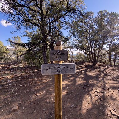

Keep your eyes open about 1/3 of a mile down the back at the bottom of a long straight stretch. The North Boundary Trail takes off to the east, while the Devisadero Loop makes a left. There is signage pointing you in the direction you want to go.

This way down is fast and fun, even for an old guy like me, and there are enough small "ups" to keep it honest. Eventually the trail breaks onto the west face, and there are numerous vantages to stop in wonderment at it all.


Somewhere in the 4.9 - 5.2-mile range (every tracker is a little different), you make it back to choice number one - the end of the loop. Your ride awaits you just 6/10ths of a mile and 400 feet downhill. I hope you left some gas in the tank.
A couple of tips -
Bring plenty of water that has electrolytes in it. At my peak a few years ago, when I was doing this in 60-65 minutes, a liter would do it. And I would strongly recommend you carry 1 liter per hour of travel time. And snacks - stay fueled. If you have kids, candy is a go. Stay hydrated, stay fueled. Do this 3 or 4 days a week before or after work, and you'll be Devis fit in no time. And when you are, it makes everything else you might want to do easier too.
Drop me a line, and I'd be happy to show you around.
Let’s talk
Chad Belvill
Associate Broker
&
Property Management
Dreamcatcher Real Estate Co. Inc
515 Gusdorf Rd. Suite 6 Taos, NM 87571
575-758-3606 o